Birmingham City 3d Model
Birmingham City 3d Model – Capturing the Heart of the West Midlands
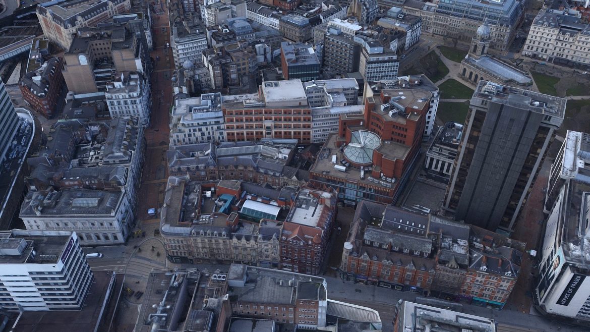
March 2018 light bathed the West Midlands, allowing a fleet of drones to capture the intricate urban tapestry of Birmingham with surgical precision. Skeye executed this massive survey using over 1,100 high-resolution aerial images to generate a digital twin of the city center. This model reflects a specific moment in time, documenting the architectural evolution of the United Kingdom’s second-largest metropolitan area.
The geometry balances computational performance with striking visual fidelity. With a lean 650,000 polygon count, the mesh maintains a lightweight profile while delivering massive spatial data for various platforms. This efficiency makes the birmingham city 3d model an ideal asset for real-time urban visualization and complex simulation environments.
Birmingham City 3d Model – Unrivaled Texture Resolution and Detail
Thirteen separate 8k texture maps skin the underlying geometry, providing a level of grit and realism rarely seen in large-scale urban reconstructions. These high-resolution samples allow viewers to identify roof tiles, road markings, and specific architectural nuances across the surveyed area. The sheer volume of pixel data ensures that the model remains sharp even when viewed from lower altitudes.
Users should toggle the high-definition settings in their viewer to appreciate the full depth of the 8k resolution. The survey covers a significant portion of the city core, providing a holistic view of the central layout. Because Skeye conducted the flight in March, the imagery remains clear and crisp, as the lack of heavy summer foliage reveals more structural detail of the buildings below.
Technical Specifications and Workflow Integration
This digital twin serves architects, urban planners, and GIS specialists who require an accurate representation of the physical world. It represents a professional-grade survey rather than a simple artistic recreation, ensuring that the proportions and placements reflect real-world coordinates. Integration into modern rendering engines remains seamless due to the optimized polygon count and standard mapping techniques.
- Optimized 650,000 polygon geometry ensures high performance in real-time applications.
- Comprehensive coverage derived from 1,100 individual aerial photographs for maximum accuracy.
- Thirteen high-fidelity 8k texture samples provide extreme close-up detail across the city.
- Accurate spatial representation based on professional Skeye survey standards from March 2018.
Versatility for Modern Visualization
Whether simulating traffic patterns or creating cinematic fly-throughs, this model provides the necessary foundation for high-end production. It captures the essence of Birmingham’s industrial heritage meeting modern redevelopment projects. The data serves as a perfect backdrop for developers looking to place new architectural proposals within a verified context.
For professionals seeking other high-detail models, consider checking out our Withings Activité Watch. You can also find more information on urban planning standards to see how these digital models assist in modern city growth and infrastructure management.
Seller Original Description
Turn on ‘HD’ in the settings for HQ textures. It may take a while to load all textures.650k polygon (low polygon count), 13 x 8k texture sample of a survey in the United Kingdom of the city Birmingham. Created from less than 1100 images and flown in March 2018.Executed by Skeye: http://skeye.eu/Contact: Timon Visser – [email protected]
Extended Use License
has been added to your cart!
have been added to your cart!
You must log in and be a buyer of this download to submit a review.
| ABOUT THE SELLER |
|
| SELLER-USER-NAME | Skeye - Aerial Survey & Inspection |
| 3D Model formats | FBX, OBJ, BLENDER, TEXTURES, Materials |
| 3D Model details | VR / AR / Low-poly, Textures, Materials, UV Mapping, Scale transformations |
| Triangles | 640.3k |
| Vertices | 664.6k |
| Category | Architecture, Places & Travel |
| Tags | 3d, 3d-model, 3dcity, 3dscan, aerial, aerial survey, aerialsurveying, birmingham, birmingham city 3d model, city, city-modeling, citymodel, citymodeling, drone, emergency, high poly, high-quality, high-resolution, highpoly, hq, hq-texturing, inspection, large-scale, low-poly-city, mesh, model, photogrammetry, realitycapture, scan, scanning, skeye, survey, surveying, tde, terra, terra-drone, terra-drone-europe, terradrone, texture, uas, uav, uk, UK city, unitedkingdom, urban, urban-planning |